


Quartzite 1 Voting District, Stevens County, Washington
About
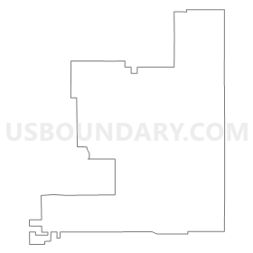
Outline
Summary
| Unique Area Identifier | 689535 |
| Name | Quartzite 1 Voting District |
| County | Stevens County |
| State | Washington |
| Area (square miles) | 183.96 |
| Land Area (square miles) | 183.85 |
| Water Area (square miles) | 0.11 |
| % of Land Area | 99.94 |
| % of Water Area | 0.06 |
| Latitude of the Internal Point | 48.32254290 |
| Longtitude of the Internal Point | -117.65398550 |
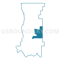
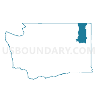
Maps

Graphs
Select a template below for downloading or customizing gragh for Quartzite 1 Voting District, Stevens County, Washington


Neighbors
Neighoring Voting District (by Name) Neighboring Voting District on the Map
- Addy Voting District, Stevens County, WA
- Arden 2 Voting District, Stevens County, WA
- Chewelah Fore Voting District, Stevens County, WA
- Cusick Voting District, Pend Oreille County, WA
- Dalkena Voting District, Pend Oreille County, WA
- Locke Voting District, Pend Oreille County, WA
- Narcisse Voting District, Stevens County, WA
- Quartzite 2 Voting District, Stevens County, WA
- Usk Voting District, Pend Oreille County, WA
- Valley 1 Voting District, Stevens County, WA
- Valley 2 Voting District, Stevens County, WA
- Waitts Lake Voting District, Stevens County, WA
Top 10 Neighboring County Subdivision (by Population) Neighboring County Subdivision on the Map
- Colville CCD, Stevens County, WA (11,113)
- Newport CCD, Pend Oreille County, WA (10,902)
- Chewelah CCD, Stevens County, WA (5,820)
- Springdale CCD, Stevens County, WA (5,013)
Top 10 Neighboring Place (by Population) Neighboring Place on the Map
Top 10 Neighboring Unified School District (by Population) Neighboring Unified School District on the Map
- Colville School District, WA (11,571)
- Chewelah School District, WA (6,060)
- Cusick School District, WA (1,989)
- Valley School District, WA (1,413)
Top 10 Neighboring State Legislative District Lower Chamber (by Population) Neighboring State Legislative District Lower Chamber on the Map
Top 10 Neighboring State Legislative District Upper Chamber (by Population) Neighboring State Legislative District Upper Chamber on the Map
Top 10 Neighboring 111th Congressional District (by Population) Neighboring 111th Congressional District on the Map
Top 10 Neighboring Census Tract (by Population) Neighboring Census Tract on the Map
- Census Tract 9513, Stevens County, WA (4,287)
- Census Tract 9511, Stevens County, WA (3,596)
- Census Tract 9508, Stevens County, WA (3,277)
- Census Tract 9702, Pend Oreille County, WA (2,649)
- Census Tract 9507, Stevens County, WA (2,543)
- Census Tract 9506, Stevens County, WA (2,265)
Top 10 Neighboring 5-Digit ZIP Code Tabulation Area (by Population) Neighboring 5-Digit ZIP Code Tabulation Area on the Map
- 99114, WA (12,018)
- 99109, WA (5,109)
- 99181, WA (1,901)
- 99101, WA (1,453)
- 99119, WA (1,204)
- 99180, WA (939)